Overland Navigator

spatialminds

New member
The admin encouraged me to start a new thread describing Overland Navigator and for discussion.

Overland Navigator essentially turns your computer into a GPS with a really big screen and USGS Topo maps. It works with traditional laptops, small/cheap "netbook" computers, tablets, and UMPCs. It is touchscreen compatible but works equally well with a mouse and keyboard. It is designed to be super easy to install/setup, intuitive to use on the trail, and easy to share tracks/trails with friends.

Detailed information about the product, screenshots, a Youtube demo, and price can be found at Spatial Minds, LLC. Please let me know if you have any questions or suggestions for improvements.

Link to the

Screenshots
image-missing.png

image-missing.png

image-missing.png


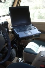
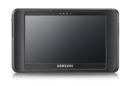
My Setup - Semi ruggedized sunlight visible UMPC running Windows XP. Attached to dash with a RAM mount. I'm using a through hull weatherproof SIRF III GPS.

I like the UMPC because I can remove it and store it in my locking drawers when I'm hiking, snowshoeing, etc. My truck is a Land Rover. I'll post additional pictures of Jeep installs soon. The Tuftab in my Land Rover would also work in a Jeep

image-missing.png

image-missing.png

image-missing.png


image-missing.png
 
Last edited:

We've just released map-packs for NY/NJ, PA, NC/SC, WI, and MI for sale through our webstore. http://spatialminds.com

The total list of map-packs that are currently available includes:

Alabama
Arkansas
Florida
Georgia
Idaho
Illinois
Indiana
Iowa
Kansas
Kentucky
Louisiana
Michigan
Mid Atlantic Region (DC, VA, WV, MD, DE)
Minnesota
Mississippi
Missouri
Montana North
Montana South
Nebraska
New England
New Mexico
New York & New Jersey
North & South Carolina
North Dakota
Ohio
Oklahoma
Pennsylvania
South Dakota
Tennessee
Texas North
Texas South
Washington
Wisconsin
Wyoming
 
Jeep install
 

Attachments

  • Quilomene_trip_017.jpg
    Quilomene_trip_017.jpg
    339.5 KB · Views: 231
  • jeffrey_OverNav_install.jpg
    jeffrey_OverNav_install.jpg
    179.5 KB · Views: 206
Last edited by a moderator:

Looks expensive, how much for the setup?

You can use a computer you already have, a UMPC, or a netbook. Touchscreen tablet computers range in price from $500 used to $4000. The setup in my truck sold new for $1700 2 years ago (ruggedized / sunlight visible screen). You can find them on eBay now. You can buy a Samsung Q1EX UMPC new for $775 or run it on a netbook for as little as $200. We put a lot of time in to insure that the keyboard support would work really easy on a Netbook.

http://www.blogcdn.com/www.engadget.com/media/2009/03/samsung-q1ex-press-mar5.png
samsungq1expressmar5-1.png


A super good SIRF III magnetic GPS sells for $36 (Globalsat BU-353). This chipset is the same as you find in the high end Garmin units such as the 60Csx. It just plugs into a USB port.

The RAM mount depends on the unit you buy and how you want to mount it... or you can just fab your own since it's usually just steel pipe and a bracket.
 
Cool! , next question. So if i already have a GPS18 or a Delorme USB beacon for the GPS, your software is what i buy and it will support that? also, will that work on a Nokia pocket PC?.. Thanks for your patience. Currently i'm using the GPS-18 plugged in to my Dell XPS M-1710 to map out locations on the ranch and trails that i wheel in from time to time. It seems to do what i need it for, i just like the idea of having the ease of the menu features rather than scrolling on a drop down menu's..
 
Overland Navigator requires an NMEA0183 compatible GPS. Garmin offers their free Garmin Spanner software to enable the GPS 18 to communicate with this non-proprietary GPS protocol (vs the proprietary Garmin binary protocol that their software uses). Similarly, Delorme has a small piece of software that comes with the GPS where you can specify that it should output NMEA0183. The $35 Globalsat BU-353 GPS is both a better GPS and less involved to setup, but the units you already have will work with some up front setup.

Overland Navigator is only compatible with Windows XP or Windows Vista so it won't run on a Nokia Pocket PC (Windows Mobile/Windows CE isn't really Windows at all). It should work GREAT on your Dell XPS M-1710 though. :)

Exactly. Overland Navigator's UI is a lot easier to use than traditional file menus. You can also setup keyboard shortcuts to map to specific waypoint symbols. For example, I have F1 set for Easy Trail, F2 set for Intermediate Trail, and F3 for Most Difficult. The arrow keys can be used to pan around, etc. Of course you can use the mouse for all of this too and the big buttons are easy to hit with a mouse.

Craig
 

Thanks for the heads up. I doubt i will ever use the Delorme GPS ever again. It's not as accurate than the GPS-18.
 
The latest version of Overland Navigator has been released. It was supposed to be a minor release but we wound up adding a number of new features as well.

Overland Navigator is topographic GPS mapping software designed to be simple to use in the field. It has an interface that makes it easy to control with a touchscreen, keyboard, or mouse. Menus auto-hide to make use of every last pixel when displaying the map. You can learn more about it at Spatial Minds, LLC

Some of the new features include:

  • APRS specific NMEA support
  • Location specific Sunrise / Sunset times
  • UTM Coordinate Display
  • Continuous GPS Track Storage to Disk
  • GPS Output to external devices
  • NMEA logging
  • Display preferences
  • High end GPS support - Track up to 64 satellites
  • Bugfixes and performance enhancements


There is a more complete description on the webpage, but here is a brief explanation of APRS display support as it is the most significant new feature. NOTE: Overland Navigator remains as simple to use as ever for non-HAM/APRS users. APRS allows a GPS and HAM radio to be combined to broadcast your postion over the airwaves. Others listen for these location beacons and can plot them on a map/GPS such as Overland Navigator. Repeaters repeat the signals so they can travel for a very long distance. Gateways take the locations and add them to a database that is accessible via the Internet by friends/family (E.g. Google Maps APRS). APRS can do much more, but this is the basic description.

The software supports the APRS specific NMEA sentences that the Kenwood D7xx radios, Tiny Tracker 4, Argent Data Systems, etc trackers output. This allows Overland Navigator to display APRS specific symbols on the map. The radio/tnc/tracker is still responsible for handling the beaconing of your location.
image-missing.png


You connect your GPS to Overland Navigator for input, then connect Overland Navigator to your tracker as it's GPS input. The tracker uses this connection to send any stations it heard back to Overland Navigator. This is, for example, the same way that you'd hook up a Garmin GPS to a tracker. There are some advantages to using Overland Navigator over a regular GPS though.
image-missing.png


In contrast to most GPS units, when new stations are heard, Overland Navigator will update the location on the map instead of adding an additional waypoint. This greatly reduces the amount of on-screen clutter and removes the need to manually delete waypoints.

The APRS waypoints automatically fade away and then expire on their own. This lets you visually see how long it's been since you last heard from an APRS station. You can set the interval. If you have it set to 40 minutes, and a symbol is just about ready to disappear then you know it's been about 40 minutes since you last heard from it.

image-missing.png


Finally, we tried to redo all the APRS symbols to have a consistent look/feel , offer more contrast with the background maps, and to be distinguishable from regular Overland Navigator waypoints (square).

Primary Symbols
image-missing.png


Secondary Symbols
image-missing.png


Craig
 
Back
Top